Atmospheric Observations (Atmospheric Sensing and Diagnosis/Hashiguchi Lab)
The 21st century is referred to as the era of the global environment. However, technologies required to measure and monitor the environmental changes of the earth are still under development. This lab is working to apply the most advanced available technology in electronics engineering and digital communications to the science of the earth's atmosphere.
To understand the current state of the earth's atmospheric environment and to make predictions about its future state, it is first necessary to carry out accurate observations of it. Thus, we are working to develop original observational instruments, and to use these to collect information about the earth's atmosphere and analyze it together with the large quantity of data available through international observation networks. We then combine this analysis with numerical simulations. All this effort is aiming to further our scientific understanding of changes to the global environment.
Academic Staff
Hiroyuki HASHIGUCHI
Professor (Research Institute for Sustainable Humanosphere)
Research Interests
Contacts
TEL: +81-774-38-3819
FAX: +81-774-31-8463
E-mail: hasiguti (at) rish.kyoto-u.ac.jp
Jun-ichi FURUMOTO
Assistant Professor (Research Institute for Sustainable Humanosphere)
Research Interests
Contacts
Masanori YABUKI
Assistant Professor (Research Institute for Sustainable Humanosphere)
Research Interests
Contacts
Introduction to R&D Topics
Basic development of GPS-based techniques observing the earth's environment
Monitoring of the earth's environment cannot be discussed today without considering observations made using artificial satellites. For example, in recent atmospheric observations, much attention is being paid to a technique (GPS occultation) that precisely and globally measures temperature and humidity profiles by analyzing the propagation (refraction) characteristics of GPS radio signals transmitted through the atmosphere by low-earth-orbit (LEO) satellites with built-in GPS receivers. In addition, by measuring the position and velocity of the LEO satellites with ultra-high precision, it is becoming possible to measure the mass distribution and temporal variation of groundwater and ice sheets. This lab engages in the development of various measurement techniques that utilize GPS radio technology, focused principally on the technique of GPS occultation. Recently, we have been doing R&D, by means of experiments, aimed at measuring in detail the 3D structure of the atmosphere around Japan, by setting up GPS receivers on the summits of mountains or on aircraft.
Figures: an environmental monitoring technique for receiving GPS radio signals via a satellite: GPS occultation observation (receiving via LEO satellite on the left) and GPS gravity measurement (receiving via LEO satellite on the right)

Development of radio, light, and acoustic wave-based observation techniques for the earth's environment
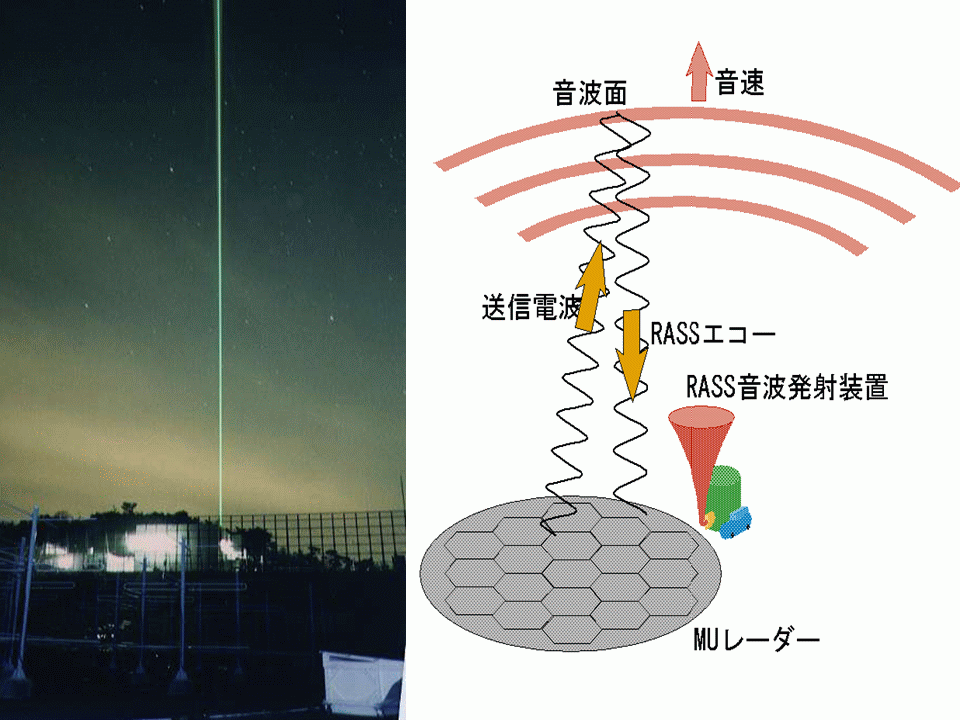
Remote sensing from the ground is also important. New technology is first developed for ground-based instruments, so these are at the cutting edge in terms of technical innovation. This lab is actively engaged in the development of measurement techniques and instruments that utilize state-of-the-art electronics technology involving radio, light, and acoustic waves. In addition, we are establishing integrated observation sites featuring these technologies both within Japan and overseas. For example, we are developing lidars that measure temperature, humidity, and aerosol levels using laser-based radars, as well as imagers that make measurements in the upper atmosphere using all-sky cameras, and radio acoustic sounding systems (RASS) that measure temperature using a method that uses a combination of acoustic waves and atmospheric radars. We are very actively engaged in R&D in these fields—just recently, for example, we developed a breakthrough technique that enables RASS to make humidity measurements.
Figures: (left) Lidar at the MU radar observatory in Shigaraki; (right) Schematic of an RASS

Monitoring the earth's atmospheric environment
In addition to conducting a wealth of observations both within Japan and overseas, we are also collecting global data from satellites. We are currently developing and setting up radars and optical observation equipment in various locations around Indonesia. In this way, as well as monitoring atmospheric changes in the earth, we are striving to unveil and illuminate atmospheric phenomena that are not currently understood.
Figure: Global distribution of atmospheric gravity waves derived from GPS occultation observations.

Development of data analysis and visualization software, and numerical simulation
The quantity and quality of available atmosphere-related data has increased rapidly over recent years, making it difficult for existing data processing software to process this data. This lab is pursuing the development of object-oriented software for processing, visualizing, and performing simulations with next-generation general data. To supplement observations, we are conducting simulations of atmospheric phenomena using large-scale parallel numerical models to investigate them more deeply.
Figure: Precipitation and wind patterns obtained by simulation

Development of dendroclimatology and image processing techniques for this
A useful method of understanding past climatic behavior involves analyzing tree-ring intervals. In order to conduct climate analysis based on tree rings in tropical regions, where little research is generally done, we are pursuing basic research in this field that incorporates image-processing techniques.
Figure: Cross-sectional image of a sunkai , a tropical tree

